1956 Map of Chandler Lake
USGS Topo · Published 1959About this map
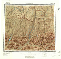
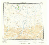
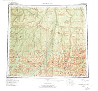
Anaktuvuk Pass serves as a critical geographic gateway through the Brooks Range, anchoring the southern portion of this mid-century survey. The landscape is defined by massive landforms like Hatbox Mesa and the Grandstand Ridge, which overlook a network of north-flowing water systems including the Chandler River and Anaktuvuk River. A lonely Tractor Trail cuts across the northern tundra, evidence of mid-twentieth-century industrial exploration in this high-latitude environment. Evidence of these early resource efforts is found at the Cabin Grandstand Test Well and another isolated Cabin near the river forks. Notable high-altitude landmarks such as Gunsight Mtn and Mount Stuve punctuate the ridges, while numerous glacial lakes like Nanushuk Lake and Shainin Lake are nestled within the mountain basins.
Find a feature on this map
149 named features on this map. Tap any name to fly to it.
Don’t see what you’re looking for? This feature index may not catch every label — zoom into the map to look around manually.
Map Details
Editions of this 1956 Chandler Lake Map
8 editions found

Other maps of this area

1951 · Sagavanirktok D-5
USGS Topo · 1:250,000

1951 · Ikpikpuk River
USGS Topo · 1:250,000

1951 · Survey Pass
USGS Topo · 1:250,000

1951 · Chandler Lake
USGS Topo · 1:250,000

1951 · Chandalar
USGS Topo · 1:250,000

1951 · Brooks
USGS Topo · 1:250,000

1951 · Killik River
USGS Topo · 1:250,000
1951 · Wiseman
USGS Topo · 1:250,000

1952 · Umiat
USGS Topo · 1:250,000

1955 · Umiat A-4
USGS Topo · 1:63,360