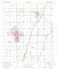
1952 Map of Chandler
USGS Topo · Published 1975About this map
Agricultural development and early urban expansion define this mid-century survey of the Salt River Valley. Chandler is shown as a concentrated hub, its downtown core organized around City Hall and marked by industrial landmarks like Grain Elevators and an Oil Tank along the Southern Pacific railroad line. The surrounding landscape is a precise grid of irrigation and transport, featuring the Western Canal, Consolidated Canal, and Eastern Canal which fueled the region's productivity.
Find a feature on this map
38 named features on this map. Tap any name to fly to it.
Don’t see what you’re looking for? This feature index may not catch every label — zoom into the map to look around manually.
Map Details
Editions of this 1952 Chandler Map
5 editions found
Other maps of this area

1904 · Desert Well
USGS Topo · 1:62,500

1906 · Desert Well
USGS Topo · 1:62,500

1907 · Sacaton
USGS Topo · 1:62,500

1913 · Mesa
USGS Topo · 1:62,500

1914 · Gila Butte
USGS Topo · 1:62,500

1915 · Mesa
USGS Topo · 1:62,500

1917 · Gila Butte
USGS Topo · 1:62,500

1952 · Tempe
USGS Topo · 1:24,000

1952 · Chandler
USGS Topo · 1:24,000

1952 · Gila Butte NW
USGS Topo · 1:24,000