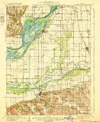
1932 Map of Chandlerville
USGS Topo · Published 1932About this map
The Illinois River dominates this landscape as it meanders past Grand Island and through a complex system of backwaters, including Stickey Lake, Anderson Lake, and Swan Lake. Further south, the Sangamon River carves its way through Chandlerville, showing a river system prior to modern engineering, where McHenry Slough and Mud Slough defined the bottomlands. The presence of numerous river landings, such as West Point Landing and Holmes Landing, highlights the era's reliance on the water for transport and commerce.
Find a feature on this map
147 named features on this map. Tap any name to fly to it.
Don’t see what you’re looking for? This feature index may not catch every label — zoom into the map to look around manually.
Map Details
Editions of this 1932 Chandlerville Map
2 editions found
Other maps of this area

1909 · Tallula
USGS Topo · 1:62,500

1918 · Vermont
USGS Topo · 1:62,500

1921 · Vermont
USGS Topo · 1:62,500

1925 · Havana
USGS Topo · 1:62,500

1926 · Beardstown
USGS Topo · 1:62,500

1929 · Arenzville
USGS Topo · 1:62,500

1929 · Manito
USGS Topo · 1:62,500

1930 · Chandlerville
USGS Topo · 1:62,500

1932 · Arenzville
USGS Topo · 1:62,500

1932 · Chandlerville
USGS Topo · 1:62,500