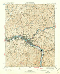
1931 Map of Charleston
USGS Topo · Published 1960About this map
Industrial and urban expansion along the Kanawha River and Elk River defines this 1931 revision of the Kanawha valley. The core of Charleston is flanked by bustling satellite communities like South Charleston, Dunbar, and Marmet, all connected by a dense network of major rail lines including the Baltimore and Ohio, New York Central, and Chesapeake and Ohio. A notable U S Navy Reservation sits prominently along the riverbank west of the city, highlighting the area's strategic importance during the early 20th century.
Find a feature on this map
125 named features on this map. Tap any name to fly to it.
Don’t see what you’re looking for? This feature index may not catch every label — zoom into the map to look around manually.
Map Details
Editions of this 1931 Charleston Map
5 editions found

Other maps of this area

1897 · Kanawha Falls
USGS Topo · 1:125,000

1899 · Charleston
USGS Topo · 1:125,000

1900 · Kanawha Falls
USGS Topo · 1:125,000

1901 · Kanawha Falls
USGS Topo · 1:125,000

1906 · Kenna
USGS Topo · 1:62,500

1906 · Winfield
USGS Topo · 1:62,500

1906 · Walton
USGS Topo · 1:62,500

1907 · Kenna
USGS Topo · 1:62,500

1907 · Walton
USGS Topo · 1:62,500

1907 · Clendenin
USGS Topo · 1:62,500