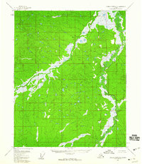
1956 Map of Charley River D-5
USGS Topo · Published 1960About this map
The Little Black River meanders through this interior Alaska wilderness, defining a landscape dominated by extensive wetlands and complex drainage patterns. This 1956 field-annotated survey reveals the intricate hydrography of the region, where the river's slow-moving course creates a wide corridor of marshes and ponds. To the west, Paddle Creek flows toward the main river channel, cutting through terrain marked by subtle elevation changes and survey markers like VABM 844 Wet. The lack of established roads or settlements in this area underscores the isolated nature of the Yukon-Koyukuk region during the mid-1950s. For researchers of Alaskan geography, the map provides a baseline for the natural hydrology of the Black River drainage system before modern environmental changes, capturing the raw state of the subarctic tundra and its seasonal watercourses.
Find a feature on this map
3 named features on this map. Tap any name to fly to it.
Don’t see what you’re looking for? This feature index may not catch every label — zoom into the map to look around manually.
Map Details
Editions of this 1956 Charley River D-5 Map
2 editions found
Other maps of this area

1951 · Charley River
USGS Topo · 1:250,000

1951 · Black River
USGS Topo · 1:250,000

1956 · Black River A-4
USGS Topo · 1:63,360

1956 · Black River A-6
USGS Topo · 1:63,360
1956 · Black River A-5
USGS Topo · 1:63,360
1956 · Charley River D-4
USGS Topo · 1:63,360
1956 · Charley River D-5
USGS Topo · 1:63,360

1956 · Charley River C-5
USGS Topo · 1:63,360

1956 · Charley River C-6
USGS Topo · 1:63,360

1956 · Black River
USGS Topo · 1:250,000