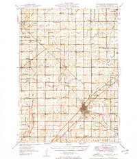
1949 Map of Charlotte
USGS Topo · Published 1949About this map
The city of Charlotte serves as the focal point of this late 1940s landscape, positioned at the junction of the Michigan Central railroad and a dense network of rural roads. The geography is defined by the winding courses of the Grand River, Thornapple River, and Battle Creek, which once dictated the placement of early settlements and agricultural boundaries. This survey reveals a remarkably high density of rural schoolhouses, including Shaytown Sch, Nickle Sch, and Strange Sch, illustrating the organized educational structure of mid-century Eaton County before district consolidation. Scattered throughout the townships of Roxand, Sunfield, and Benton are small crossroads communities like Gresham and Hoytville, alongside essential local landmarks such as the Town Hall, County Farm, and the West Benton Ch. Genealogists will find significant value in the clearly marked cemeteries, such as Maple Hill Cem and Spaulding Cem, situated near traditional family-named schools and churches.
Find a feature on this map
96 named features on this map. Tap any name to fly to it.
Don’t see what you’re looking for? This feature index may not catch every label — zoom into the map to look around manually.
Map Details
Editions of this 1949 Charlotte Map
3 editions found

Other maps of this area

1910 · Lansing
USGS Topo · 1:62,500

1912 · Lansing
USGS Topo · 1:62,500

1916 · Ionia
USGS Topo · 1:62,500

1918 · Battle Creek
USGS Topo · 1:62,500

1918 · Ionia
USGS Topo · 1:62,500

1919 · Springport
USGS Topo · 1:62,500

1921 · Springport
USGS Topo · 1:62,500

1921 · Marshall
USGS Topo · 1:62,500

1923 · Marshall
USGS Topo · 1:62,500

1927 · De Witt
USGS Topo · 1:62,500