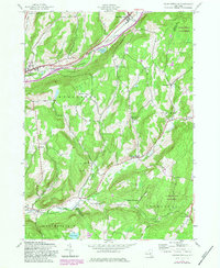
1943 Map of Charlotteville
USGS Topo · Published 1983About this map
Charlotteville sits at the heart of this mid-century landscape where the Otsego Co Schoharie Co line divides a network of rural school districts and family landmarks. The northern corridor is defined by the Delaware and Hudson Railroad and Schenevus Creek, connecting Worcester and East Worcester. This region is characterized by a dense distribution of one-room schoolhouses, such as Oliver Sch and Hall Sch, which were often the focal point of these small farming communities. To the south, the terrain climbs toward Clapper Hollow and the Lutheranville State Forest. Genealogists will find significant value in the mapped cemeteries, including Stuckey Cem and Dugway Cem, which anchor the small crossroads of Barton Corners and South Worcester during a period of transition for New York’s rural interior.
Find a feature on this map
43 named features on this map. Tap any name to fly to it.
Don’t see what you’re looking for? This feature index may not catch every label — zoom into the map to look around manually.
Map Details
Editions of this 1943 Charlotteville Map
4 editions found
Other maps of this area

1904 · Richmondville
USGS Topo · 1:62,500

1904 · Hobart
USGS Topo · 1:62,500

1907 · Cooperstown
USGS Topo · 1:62,500

1909 · Cooperstown
USGS Topo · 1:62,500

1909 · Delhi
USGS Topo · 1:62,500

1911 · Delhi
USGS Topo · 1:62,500

1943 · South Valley
USGS Topo · 1:24,000

1943 · Westford
USGS Topo · 1:24,000

1943 · Charlotteville
USGS Topo · 1:24,000
1943 · Schenevus
USGS Topo · 1:24,000