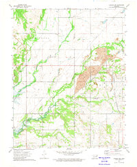
1972 Map of Chelsea NW
USGS Topo · Published 1974About this map
The Coker Hills and the winding course of Salt Creek define the landscape of this northeastern Oklahoma region in the early 1970s. The map illustrates a transitional economy where traditional agricultural land is interspersed with heavy extractive industry, notably the large Strip Mine operations and scattered Oil Field developments. Transportation and infrastructure are prominent, with a large Pipeline cutting across the terrain and the St Louis - San Francisco railroad traversing the eastern edge. Local community life is rooted in landmarks like the Happy Hollow Community Center and Lightning Creek Ch. Genealogists may find value in the presence of the Mc Mains Cem and Madden Cem, which remain as markers of the area's early residents. To the southwest, the waters of Oologah Lake represent a major geographic change to the river drainage system.
Find a feature on this map
25 named features on this map. Tap any name to fly to it.
Don’t see what you’re looking for? This feature index may not catch every label — zoom into the map to look around manually.
Map Details
Editions of this 1972 Chelsea NW Map
2 editions found
Other maps of this area

1901 · Nowata
USGS Topo · 1:125,000

1901 · Vinita
USGS Topo · 1:125,000

1913 · Vinita
USGS Topo · 1:125,000

1914 · Nowata
USGS Topo · 1:125,000

1954 · Tulsa
USGS Topo · 1:250,000

1958 · Tulsa
USGS Topo · 1:250,000

1963 · Tulsa
USGS Topo · 1:250,000

1970 · Chelsea
USGS Topo · 1:24,000

1970 · White Oak
USGS Topo · 1:24,000
1970 · Winganon
USGS Topo · 1:24,000