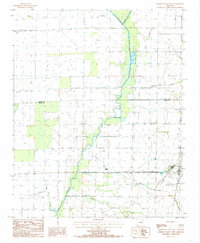
1984 Map of Cherry Valley West
USGS Topo · Published 1985About this map
Cherry Valley and the surrounding agricultural lowlands of the Mississippi Alluvial Plain appear here during the mid-1980s. The landscape is defined by an intricate network of waterways and drainage infrastructure designed to manage the flat terrain, including the meandering L'Anguille River and its various tributaries like Wolf Creek and Prairie Creek. The influence of the Missouri Pacific railroad is evident, providing a vital transportation artery for the region's rural economy. Along the Poinsett and Cross County line, the map documents a series of siphons, flumes, and ditches such as Mc Coy Ditch that highlight the intensive water management necessary for local cultivation. Smaller natural features like Wolf Pen Slough and Hydrick Creek intersect the grid-like pattern of roads and field boundaries, illustrating the persistent presence of the original drainage patterns amidst modern development.
Find a feature on this map
13 named features on this map. Tap any name to fly to it.
Don’t see what you’re looking for? This feature index may not catch every label — zoom into the map to look around manually.
Map Details
Editions of this 1984 Cherry Valley West Map
2 editions found
Other maps of this area

1939 · Vanndale
USGS Topo · 1:62,500

1939 · Weiner
USGS Topo · 1:62,500

1940 · Princedale
USGS Topo · 1:62,500

1940 · Dee
USGS Topo · 1:62,500

1953 · Memphis
USGS Topo · 1:250,000

1956 · Memphis
USGS Topo · 1:250,000

1956 · Princedale
USGS Topo · 1:62,500

1958 · Dee
USGS Topo · 1:62,500

1958 · Vanndale
USGS Topo · 1:62,500

1959 · Weiner
USGS Topo · 1:62,500