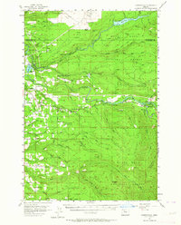
1955 Map of Cherryville
USGS Topo · Published 1964About this map
The Sandy River and Bull Run Reservoir define the hydrological landscape of this mid-century survey, where the river's path carves through the foothills of the Mount Hood National Forest. Small settlements like Cherryville and Brightwood dot the corridor along Highway 26, providing a record of rural communities before modern suburban expansion. The infrastructure of the era is evident in the presence of the Little Sandy Guard Sta and the Bull Run Sch, alongside specialized locales like Camp Namanu and Camp Howard. The topography is marked by significant landmarks such as the Devils Backbone and Lookout Point, illustrating the transition from the valley floor to the high ridges of the Cascades. These details capture the intersection of forestry management, water utility, and early mountain tourism.
Find a feature on this map
53 named features on this map. Tap any name to fly to it.
Don’t see what you’re looking for? This feature index may not catch every label — zoom into the map to look around manually.
Map Details
Editions of this 1955 Cherryville Map
3 editions found

Other maps of this area

1911 · Boring
USGS Topo · 1:48,000

1914 · Boring
USGS Topo · 1:62,500

1916 · Estacada
USGS Topo · 1:125,000

1918 · Troutdale
USGS Topo · 1:62,500

1924 · Mount Hood
USGS Topo · 1:125,000

1926 · Hood River
USGS Topo · 1:125,000

1927 · Mount Hood
USGS Topo · 1:125,000

1929 · Hood River
USGS Topo · 1:125,000

1934 · Troutdale
USGS Topo · 1:48,000

1940 · Boring
USGS Topo · 1:62,500