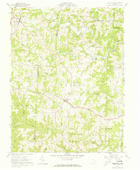
1961 Map of Chesterhill
USGS Topo · Published 1973About this map
High ridges and deep stream valleys define this portion of the Appalachian Plateau, where the border of the Wayne National Forest meets active farm and timber lands. This 1961 field check captures the rural character of communities like Bartlett and Chesterhill before modern infrastructure expanded. The map reveals a landscape heavily dotted with rural religious and memorial sites, including the Friends Cem and Quaker Cem, reflecting the area's Quaker heritage and deep-rooted settlement history. Significant watercourses like West Branch Wolf Creek and Little Hocking River snake through the terrain, historically driving the location of small hubs such as Patten Mills. The detailed topography includes notable elevations like Aldridge Hill and the numerous small tributaries such as Shrader Run and Marietta Run that carved this complex drainage network over millennia.
Find a feature on this map
49 named features on this map. Tap any name to fly to it.
Don’t see what you’re looking for? This feature index may not catch every label — zoom into the map to look around manually.
Map Details
Editions of this 1961 Chesterhill Map
4 editions found
Other maps of this area

1902 · Parkersburg
USGS Topo · 1:62,500

1904 · Parkersburg
USGS Topo · 1:62,500

1904 · Chesterhill
USGS Topo · 1:62,500

1906 · Chesterhill
USGS Topo · 1:62,500

1909 · Caldwell
USGS Topo · 1:62,500

1910 · Mc Connelsville
USGS Topo · 1:62,500

1912 · Caldwell
USGS Topo · 1:62,500

1949 · Clarksburg
USGS Topo · 1:250,000

1956 · Clarksburg
USGS Topo · 1:250,000

1960 · Watertown
USGS Topo · 1:24,000