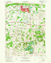
1962 Map of Chesterton
USGS Topo · Published 1969About this map
The Little Calumet River and Calumet River wind through the northern reaches of Porter County, defining a landscape where industrial infrastructure meets established residential settlements. In the early 1960s, the rail network was particularly dense here, featuring the New York Central, Wabash, and Baltimore and Ohio lines intersecting near Chesterton and Porter. This confluence of rail and road, including the Indiana East-West Toll Road, supported outlying communities like Crocker and Woodville. South of the main towns, the topography shifts toward a high concentration of glacial lakes such as Flint Lake, Long Lake, and Mink Lake. Local history is anchored by several long-standing institutions, including Augsburg Ch, St Patricks Cem, and the Tratebas Mill located along Damon Run. These features, alongside family-named landmarks like Graham Woods and Haglund, provide a detailed record of the mid-century Porter County landscape.
Find a feature on this map
113 named features on this map. Tap any name to fly to it.
Don’t see what you’re looking for? This feature index may not catch every label — zoom into the map to look around manually.
Map Details
Editions of this 1962 Chesterton Map
4 editions found
Other maps of this area

1934 · Porter
USGS Topo · 1:48,000

1940 · Porter
USGS Topo · 1:62,500

1953 · Palmer
USGS Topo · 1:24,000

1953 · Wanatah
USGS Topo · 1:24,000

1953 · Garyton
USGS Topo · 1:24,000

1953 · Westville
USGS Topo · 1:24,000

1953 · Valparaiso
USGS Topo · 1:24,000

1953 · Ogden Dunes
USGS Topo · 1:24,000

1953 · Chesterton
USGS Topo · 1:24,000

1953 · Dune Acres
USGS Topo · 1:24,000