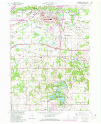
1962 Map of Chesterton
USGS Topo · Published 1980About this map
The Little Calumet River and its accompanying marshlands dominate the northern landscape of this region, reflecting the transition between the lakefront dunes and the developed interior of Porter County. The town of Chesterton sits as a central hub, surrounded by smaller residential developments like Western Acres and Meadowbrook. The era's transportation infrastructure is heavily represented by a dense network of major rail lines, including the Conrail and Elgin Joliet and Eastern, alongside the Indiana East-West Toll Road.
Find a feature on this map
82 named features on this map. Tap any name to fly to it.
Don’t see what you’re looking for? This feature index may not catch every label — zoom into the map to look around manually.
Map Details
Editions of this 1962 Chesterton Map
4 editions found
Other maps of this area

1934 · Porter
USGS Topo · 1:48,000

1940 · Porter
USGS Topo · 1:62,500

1953 · Palmer
USGS Topo · 1:24,000

1953 · Wanatah
USGS Topo · 1:24,000

1953 · Garyton
USGS Topo · 1:24,000

1953 · Westville
USGS Topo · 1:24,000

1953 · Valparaiso
USGS Topo · 1:24,000

1953 · Ogden Dunes
USGS Topo · 1:24,000

1953 · Chesterton
USGS Topo · 1:24,000

1953 · Dune Acres
USGS Topo · 1:24,000