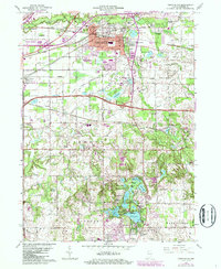
1962 Map of Chesterton
USGS Topo · Published 1987About this map
Porter County is defined by a dense intersection of heavy rail and emerging residential growth in the mid-20th century. The town of Chesterton serves as the hub, bounded to the north by the Indiana Dunes National Lakeshore and the Calumet River. This era shows a transition toward modern suburbanization with developments like Brummitt Acres and Western Acres appearing alongside established landmarks like Augsburg Ch and the Chesterton Cemetery. To the south, the landscape is punctuated by a string of glacial lakes including Flint Lake and Long Lake, where lakeside communities like Edgewater and Burlington Beach reflect the region's recreational appeal. The industrial infrastructure remains prominent, with the Conrail, Baltimore and Ohio, and Elgin Joliet and Eastern railroads carving through the terrain near Burns Harbor and Crocker, illustrating the area's role as a vital transportation corridor.
Find a feature on this map
73 named features on this map. Tap any name to fly to it.
Don’t see what you’re looking for? This feature index may not catch every label — zoom into the map to look around manually.
Map Details
Editions of this 1962 Chesterton Map
4 editions found
Other maps of this area

1934 · Porter
USGS Topo · 1:48,000

1940 · Porter
USGS Topo · 1:62,500

1953 · Palmer
USGS Topo · 1:24,000

1953 · Wanatah
USGS Topo · 1:24,000

1953 · Garyton
USGS Topo · 1:24,000

1953 · Westville
USGS Topo · 1:24,000

1953 · Valparaiso
USGS Topo · 1:24,000

1953 · Ogden Dunes
USGS Topo · 1:24,000

1953 · Chesterton
USGS Topo · 1:24,000

1953 · Dune Acres
USGS Topo · 1:24,000