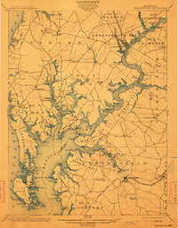
1901 Map of Chestertown
USGS Topo · Published 1913About this map
The Chester River serves as the central artery for this Eastern Shore landscape, winding past the county seats of Chestertown in Kent and Centerville in Queen Anne. At the start of the twentieth century, the region's economy relies heavily on water-borne transit and rail connections. Numerous landings and wharves, such as Learys Mill Whf. and Bogles Wharf, punctuate the deeply indented shoreline of Langford Bay and the various necks of land like Wilmer Neck and Corsica Neck.
Find a feature on this map
151 named features on this map. Tap any name to fly to it.
Don’t see what you’re looking for? This feature index may not catch every label — zoom into the map to look around manually.
Map Details
Editions of this 1901 Chestertown Map
4 editions found
Other maps of this area

1892 · Annapolis
USGS Topo · 1:62,500

1893 · North Point
USGS Topo · 1:62,500

1893 · Gunpowder
USGS Topo · 1:62,500

1898 · Choptank
USGS Topo · 1:125,000

1898 · Tolchester
USGS Topo · 1:125,000

1899 · Dover
USGS Topo · 1:125,000

1900 · Cecilton
USGS Topo · 1:62,500

1900 · Betterton
USGS Topo · 1:62,500

1901 · Chestertown
USGS Topo · 1:62,500

1901 · Gunpowder
USGS Topo · 1:62,500