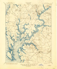
1901 Map of Chestertown
USGS Topo · Published 1945About this map
The Chester River dominates this coastal landscape at the turn of the century, serving as a critical boundary between Kent and Queen Anne's counties. Extensive waterfront infrastructure reflects the era's maritime economy, with numerous landings and points of interest such as Learys Mill Whf, Vickers Whf, and Tolchester Beach. The inland geography is defined by prominent necks of land, including Poplar Neck, Piney Neck, and Eastern Neck, which are deeply incised by tidal creeks like Gray's Inn Creek and Langford Creek.
Find a feature on this map
138 named features on this map. Tap any name to fly to it.
Don’t see what you’re looking for? This feature index may not catch every label — zoom into the map to look around manually.
Map Details
Editions of this 1901 Chestertown Map
4 editions found
Other maps of this area

1892 · Annapolis
USGS Topo · 1:62,500

1893 · North Point
USGS Topo · 1:62,500

1893 · Gunpowder
USGS Topo · 1:62,500

1898 · Choptank
USGS Topo · 1:125,000

1898 · Tolchester
USGS Topo · 1:125,000

1899 · Dover
USGS Topo · 1:125,000

1900 · Cecilton
USGS Topo · 1:62,500

1900 · Betterton
USGS Topo · 1:62,500

1901 · Chestertown
USGS Topo · 1:62,500

1901 · Gunpowder
USGS Topo · 1:62,500