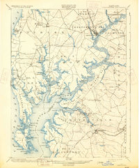
1901 Map of Chestertown
USGS Topo · Published 1931About this map
Chestertown and Centerville anchor this detailed survey of the Eastern Shore, where the tidal fingers of the Chester River divide the landscape into a series of agricultural necks. The region’s late 19th-century economy is visible through the Baltimore and Delaware Bay RR line terminating at Chestertown, while the sprawling shoreline is dotted with local landmarks like Bogles Wharf and Spaniards Point. The map provides a look at the intricate geography of Langford Bay and the numerous small landings that once served as vital links for trade and travel along the Chesapeake. Inland, the survey reveals a network of established crossroads and hamlets such as Kennedyville, Rockhall, and Pomona, many associated with the surrounding districts like No. 6 and No. 4. The complex maritime boundary between Kent and Queen Anne counties is clearly traced through the winding river channel and Eastern Neck Island.
Find a feature on this map
135 named features on this map. Tap any name to fly to it.
Don’t see what you’re looking for? This feature index may not catch every label — zoom into the map to look around manually.
Map Details
Editions of this 1901 Chestertown Map
4 editions found
Other maps of this area

1892 · Annapolis
USGS Topo · 1:62,500

1893 · North Point
USGS Topo · 1:62,500

1893 · Gunpowder
USGS Topo · 1:62,500

1898 · Choptank
USGS Topo · 1:125,000

1898 · Tolchester
USGS Topo · 1:125,000

1899 · Dover
USGS Topo · 1:125,000

1900 · Cecilton
USGS Topo · 1:62,500

1900 · Betterton
USGS Topo · 1:62,500

1901 · Chestertown
USGS Topo · 1:62,500

1901 · Gunpowder
USGS Topo · 1:62,500