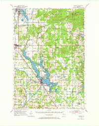
1951 Map of Chetek
USGS Topo · Published 1969About this map
Chetek and Rice Lake anchor this 1951 survey, a landscape defined by an extensive network of interconnected waters including Prairie Lake, Pokegama Lake, and Tenmile Lake. The region is a study in mid-century rural infrastructure, where three major railroads—the North Western, the Minneapolis Sault Ste Marie and Atlantic, and the Chicago St Paul Minneapolis and Omaha—intersect to serve the lakeside communities.
Find a feature on this map
99 named features on this map. Tap any name to fly to it.
Don’t see what you’re looking for? This feature index may not catch every label — zoom into the map to look around manually.
Map Details
Editions of this 1951 Chetek Map
2 editions found

Other maps of this area

1945 · Meteor
USGS Topo · 1:48,000

1948 · Weyerhauser
USGS Topo · 1:48,000

1949 · Meteor
USGS Topo · 1:48,000

1949 · Rice Lake
USGS Topo · 1:48,000

1949 · Bloomer
USGS Topo · 1:62,500

1949 · New Auburn
USGS Topo · 1:62,500

1949 · Ridgeland
USGS Topo · 1:62,500

1950 · Weyerhauser
USGS Topo · 1:48,000

1951 · Bloomer
USGS Topo · 1:62,500

1951 · Ridgeland
USGS Topo · 1:62,500