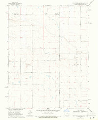
1969 Map of Cheyenne Wells 4 SE
USGS Topo · Published 1971About this map
White Woman Creek meanders through the heart of this high plains landscape at the border of Colorado and Kansas in the late 1960s. The terrain is characterized by broad drainage patterns and intermittent water features, including a small Cem and a Gravel Pit that mark the local human activity and industry of the era. The area is intersected by several county and state boundaries, including the line between Cheyenne County and Kiowa County and the intersection of Kiowa and Greeley County. To the east, the Colony settlement appears near the Kansas state line, illustrating the sparse but organized land use of this prairie region. This survey, conducted in cooperation with State of Kansas agencies, provides a clear view of the section lines and topography before more modern development altered the rural landscape.
Find a feature on this map
8 named features on this map. Tap any name to fly to it.
Don’t see what you’re looking for? This feature index may not catch every label — zoom into the map to look around manually.
Map Details
Editions of this 1969 Cheyenne Wells 4 SE Map
3 editions found
Other maps of this area

1890 · Granada
USGS Topo · 1:125,000

1892 · Cheyenne Wells
USGS Topo · 1:125,000

1892 · Granada
USGS Topo · 1:125,000

1894 · Cheyenne Wells
USGS Topo · 1:125,000

1894 · Granada
USGS Topo · 1:125,000

1954 · Lamar
USGS Topo · 1:250,000

1955 · Scott City
USGS Topo · 1:250,000

1958 · Lamar
USGS Topo · 1:250,000

1958 · Scott City
USGS Topo · 1:250,000

1968 · Sharon Springs 3 NW
USGS Topo · 1:24,000