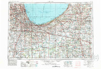
1953 Map of Chicago
USGS Topo · Published 1984About this map
Lake Michigan anchors the northern reaches of this mid-century landscape, where the heavy industry of Gary and Hammond meets the distinct glacial geography of the Indiana Dunes and the Valparaiso Moraine. The map illustrates the intense rail and road infrastructure radiating from Chicago, including the Indiana Toll Road and numerous major lines like the Pennsylvania RR and New York Central RR.
Find a feature on this map
269 named features on this map. Tap any name to fly to it.
Don’t see what you’re looking for? This feature index may not catch every label — zoom into the map to look around manually.
Map Details
Editions of this 1953 Chicago Map
5 editions found

Other maps of this area

1889 · Chicago
USGS Topo · 1:62,500

1890 · Des Plaines
USGS Topo · 1:62,500

1891 · Chicago
USGS Topo · 1:62,500

1891 · Riverside
USGS Topo · 1:62,500

1892 · Joliet
USGS Topo · 1:62,500

1892 · Calumet
USGS Topo · 1:62,500

1892 · Wilmington
USGS Topo · 1:62,500

1893 · Calumet
USGS Topo · 1:62,500

1893 · Riverside
USGS Topo · 1:62,500

1894 · Des Plaines
USGS Topo · 1:62,500