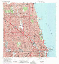
1963 Map of Chicago Loop
USGS Topo · Published 1984About this map
Lake Michigan dominates the eastern edge of this dense urban study, where the Chicago River and its Turning Basin anchor the industrial and maritime core of the city. The landscape is a sprawling grid of neighborhoods defined by a massive concentration of civic and religious institutions, including several massive burial grounds such as Rosehill Cemetery, Graceland Cemetery, and the Bohemian National Cemetery. The shoreline reveals significant 1960s infrastructure, from the Filtration Plant and Navy Pier to the sports and science hubs at Soldier Field and the Adler Planetarium. High-speed transit routes like the Kennedy Expwy and Eisenhower Expwy carve through the city, intersecting the older rail networks of the Chicago and North Western and the C & N W. This 1963 survey captures a moment of intense postwar density, documenting dozens of local schools and hospitals serving the diverse communities of Chicago.
Find a feature on this map
77 named features on this map. Tap any name to fly to it.
Don’t see what you’re looking for? This feature index may not catch every label — zoom into the map to look around manually.
Map Details
Editions of this 1963 Chicago Loop Map
3 editions found
Other maps of this area

1889 · Chicago
USGS Topo · 1:62,500

1891 · Chicago
USGS Topo · 1:62,500

1891 · Riverside
USGS Topo · 1:62,500

1893 · Riverside
USGS Topo · 1:62,500

1899 · Evanston
USGS Topo · 1:62,500

1900 · Chicago
USGS Topo · 1:62,500

1900 · Riverside
USGS Topo · 1:62,500

1900 · Highwood
USGS Topo · 1:62,500

1901 · Riverside
USGS Topo · 1:62,500

1901 · Chicago
USGS Topo · 1:62,500
Featured Places
- Chicago, IL
- Lincolnwood, IL
- Lake View Township, Chicago
- West Chicago Township, Chicago
- Jefferson Township, Chicago