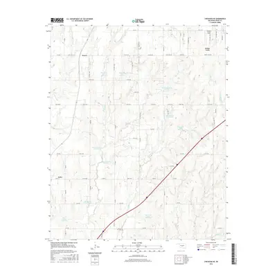
2016 Map of Chickasha NE
USGS Topo · Published 2016About this map
Amber and Bridge Creek anchor this Grady County landscape, where modern infrastructure meets a complex water management system. The terrain is defined by the branching tributaries of W Bitter Cr and Brushy Cr, which feed into an extensive series of flood control structures including Bitter Creek Site 6 Reservoir, Bitter Creek Site 12 Reservoir, and Bitter Creek Site 4 Reservoir.
Find a feature on this map
71 named features on this map. Tap any name to fly to it.
Don’t see what you’re looking for? This feature index may not catch every label — zoom into the map to look around manually.
Map Details
Editions of this 2016 Chickasha NE Map
This is the sole edition of this map. No revisions or reprints were ever made.
Other maps of this area

1893 · Oklahoma City
USGS Topo · 1:62,500

1893 · Minco
USGS Topo · 1:62,500

1904 · Chickasha
USGS Topo · 1:125,000

1954 · Oklahoma City
USGS Topo · 1:250,000

1956 · Oklahoma City
USGS Topo · 1:62,500

1957 · Oklahoma City
USGS Topo · 1:250,000

1963 · Oklahoma City
USGS Topo · 1:250,000
1965 · Dibble
USGS Topo · 1:24,000
1965 · Blanchard
USGS Topo · 1:24,000
1965 · Oklahoma City SW
USGS Topo · 1:24,000