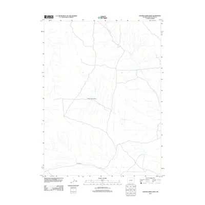
2012 Map of Chicken Creek West
USGS Topo · Published 2012About this map
Chicken Springs Basin defines the central topography of this high desert region in Sweetwater County, where ephemeral water systems like Chicken Cr and Alkali Cr carve subtle drainage patterns across the landscape. The human footprint in this part of Wyoming is sparse, centered primarily on the southern transit corridor along Bitter Creek Rd and the localized operations at the Erickson-Kent Ranch. This 2012 survey illustrates a rugged ranching landscape largely unchanged by modern development, where the eponymous Chicken Springs remains a vital landmark in an otherwise arid expanse. The map is an essential reference for understanding the distribution of water resources and isolated ranching outposts in the southwest Wyoming interior during the early 21st century.
Find a feature on this map
6 named features on this map. Tap any name to fly to it.
Don’t see what you’re looking for? This feature index may not catch every label — zoom into the map to look around manually.
Map Details
Editions of this 2012 Chicken Creek West Map
This is the sole edition of this map. No revisions or reprints were ever made.
Other maps of this area

1954 · Rock Springs
USGS Topo · 1:250,000

1958 · Rock Springs
USGS Topo · 1:250,000

1962 · Rock Springs
USGS Topo · 1:250,000

1963 · Erickson-Kent Ranch
USGS Topo · 1:24,000

1963 · Scrivner Butte
USGS Topo · 1:24,000

1968 · Chicken Creek East
USGS Topo · 1:24,000
1968 · Chicken Creek SW
USGS Topo · 1:24,000

1968 · Pine Butte
USGS Topo · 1:24,000

1968 · Sand Butte Rim SE
USGS Topo · 1:24,000
1968 · Burley Draw
USGS Topo · 1:24,000