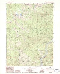
1986 Map of Chicken Hawk Hill
USGS Topo · Published 1986About this map
The Sacramento River carves through the eastern edge of this landscape, marking a vital corridor where the settlement of Gibson sits alongside State Hwy 13. This mid-1980s survey documents a region defined by the intersection of the Trinity National Forest and Shasta National Forest, where the complex drainage systems of Mears Creek and Boulder Creek feed into the river valley. Higher elevations are marked by distinctive alpine features like Twin Lakes and Tamarack Lake near Mount Eddy, while lower slopes reveal traces of smaller-scale extraction and natural springs. The presence of Shiloah Mineral Springs and numerous Prospect labels suggests a history of both recreational interest and resource exploration in these steep California mountainsides, documented here just as modern environmental management was becoming established.
Find a feature on this map
30 named features on this map. Tap any name to fly to it.
Don’t see what you’re looking for? This feature index may not catch every label — zoom into the map to look around manually.
Map Details
Editions of this 1986 Chicken Hawk Hill Map
2 editions found
Other maps of this area

1886 · Shasta
USGS Topo · 1:250,000

1890 · Red Bluff
USGS Topo · 1:250,000

1894 · Red Bluff
USGS Topo · 1:250,000

1894 · Shasta
USGS Topo · 1:250,000

1901 · Redding
USGS Topo · 1:125,000

1913 · Weaverville
USGS Topo · 1:125,000

1923 · Sawyers Bar
USGS Topo · 1:125,000

1931 · Etna
USGS Topo · 1:96,000

1934 · Etna
USGS Topo · 1:125,000

1935 · Dunsmuir
USGS Topo · 1:125,000