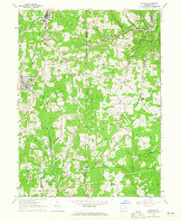
1964 Map of Chicora
USGS Topo · Published 1965About this map
Industrial activity and rural settlement define the borderlands of Butler and Armstrong counties during the mid-1960s. The landscape is heavily marked by energy extraction, with extensive strip mines and clusters of oil and gas wells concentrated around Chicora and Karns City. This industrial presence contrasts with the traditional rural network of country churches like St Patricks Ch and Gem Berean Ch, alongside established institutions like the Home for the Aged near the southern boundary. Transport is anchored by the Baltimore and Ohio railroad, which follows the natural corridors carved by Buffalo Creek and Sugar Creek. The rugged terrain of Bradys Bend and the presence of State Game Lands No 105 illustrate the area's transition from intensive mining back to natural conservation and recreation areas.
Find a feature on this map
41 named features on this map. Tap any name to fly to it.
Don’t see what you’re looking for? This feature index may not catch every label — zoom into the map to look around manually.
Map Details
Editions of this 1964 Chicora Map
Other maps of this area

1900 · Kittanning
USGS Topo · 1:62,500

1902 · Kittanning
USGS Topo · 1:62,500

1907 · Foxburg
USGS Topo · 1:62,500

1908 · Foxburg
USGS Topo · 1:62,500

1909 · Butler
USGS Topo · 1:62,500

1910 · Hilliards
USGS Topo · 1:62,500

1911 · Butler
USGS Topo · 1:62,500

1912 · Hilliards
USGS Topo · 1:62,500

1944 · Hilliards
USGS Topo · 1:62,500

1953 · Pittsburgh
USGS Topo · 1:250,000