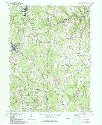
1964 Map of Chicora
USGS Topo · Published 1993About this map
Industrial activity and rural settlement patterns intersect across the Butler and Armstrong County line in this western Pennsylvania landscape. The terrain is characterized by a dense network of gas and oil wells, interspersed with extensive strip mine operations and significant areas of reclaimed strip mine land. The B & O RR corridor supports established communities like Karns City and Chicora, while the rugged valley of Sugar Creek winds toward Bradys Bend in the northeast. This area shows a complex transition from traditional extraction to modern land use, featuring the Ridgeview Country Club alongside active tipple sites and long-standing institutions like the Home for the Aged. Small hamlets such as Kepples Corners and Rattigan serve as focal points for the surrounding agricultural and industrial workforce, connected by a network of local roads and prominent utility pipelines.
Find a feature on this map
52 named features on this map. Tap any name to fly to it.
Don’t see what you’re looking for? This feature index may not catch every label — zoom into the map to look around manually.
Map Details
Editions of this 1964 Chicora Map
Other maps of this area

1900 · Kittanning
USGS Topo · 1:62,500

1902 · Kittanning
USGS Topo · 1:62,500

1907 · Foxburg
USGS Topo · 1:62,500

1908 · Foxburg
USGS Topo · 1:62,500

1909 · Butler
USGS Topo · 1:62,500

1910 · Hilliards
USGS Topo · 1:62,500

1911 · Butler
USGS Topo · 1:62,500

1912 · Hilliards
USGS Topo · 1:62,500

1944 · Hilliards
USGS Topo · 1:62,500

1953 · Pittsburgh
USGS Topo · 1:250,000