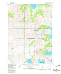
1963 Map of Chignik A-3
USGS Topo · Published 1983About this map
Alaska Peninsula National Wildlife Refuge dominates this mid-century topographic survey, documenting the intricate coastal geography and inland water systems south of Chignik Lake. The landscape is defined by the heavy drainage of the Clark River and the W Fk Chignik River, which feed into the northern basins. Along the eastern shore, a series of complex indentations form Windy Bay, Foot Bay, and Fishhook Bay, while Ivan Bay and Fishrack Bay carve into the southern coastline.
Find a feature on this map
14 named features on this map. Tap any name to fly to it.
Don’t see what you’re looking for? This feature index may not catch every label — zoom into the map to look around manually.
Map Details
Editions of this 1963 Chignik A-3 Map
3 editions found
Other maps of this area

1951 · Stepovak Bay
USGS Topo · 1:250,000

1963 · Stepovak Bay D-2
USGS Topo · 1:63,360

1963 · Chignik B-2
USGS Topo · 1:63,360

1963 · Chignik A-4
USGS Topo · 1:63,360

1963 · Stepovak Bay D-4
USGS Topo · 1:63,360

1963 · Chignik A-2
USGS Topo · 1:63,360

1963 · Chignik B-4
USGS Topo · 1:63,360

1963 · Chignik A-3
USGS Topo · 1:63,360

1963 · Chignik B-3
USGS Topo · 1:63,360

1963 · Chignik
USGS Topo · 1:250,000