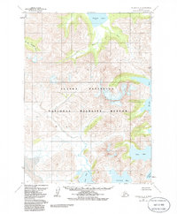
1963 Map of Chignik A-3
USGS Topo · Published 1986About this map
Alaska Peninsula National Wildlife Refuge dominates this section of the peninsula, where high coastal ridges descend sharply into the complex inlets of the North Pacific. The drainage systems of the Clark River and the W Fk Chignik River converge towards the northwest, feeding into the southern reaches of Chignik Lake. This hydrographic pattern reveals a landscape of high-elevation runoff that sustains the region's inland water bodies before they exit towards the Bristol Bay watershed.
Find a feature on this map
12 named features on this map. Tap any name to fly to it.
Don’t see what you’re looking for? This feature index may not catch every label — zoom into the map to look around manually.
Map Details
Editions of this 1963 Chignik A-3 Map
3 editions found
Other maps of this area

1951 · Stepovak Bay
USGS Topo · 1:250,000

1963 · Stepovak Bay D-2
USGS Topo · 1:63,360

1963 · Chignik B-2
USGS Topo · 1:63,360

1963 · Chignik A-4
USGS Topo · 1:63,360

1963 · Stepovak Bay D-4
USGS Topo · 1:63,360

1963 · Chignik A-2
USGS Topo · 1:63,360

1963 · Chignik B-4
USGS Topo · 1:63,360

1963 · Chignik A-3
USGS Topo · 1:63,360

1963 · Chignik B-3
USGS Topo · 1:63,360

1963 · Chignik
USGS Topo · 1:250,000