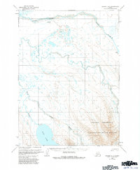
1963 Map of Chignik A-7
USGS Topo · Published 1984About this map
Alaska Peninsula terrain dominates this 1963 survey, characterized by the complex drainage systems of the Sandy River and Bear River basins. The landscape is a mix of braided river channels and scattered wetlands, reaching south to the shores of Bear Lake. Human activity in this remote region is indicated by isolated infrastructure, such as the Sandy River Landing Strip and a separate Landing Strip near the lake. A solitary Drill Hole and a remote Cabin provide evidence of early exploration and temporary habitation within what is now the Alaska Peninsula National Wildlife Refuge. The map captures the transitional period after the 1957 aerial photography and before the 1981 minor revisions, preserving the mid-century wilderness character of the peninsula.
Find a feature on this map
12 named features on this map. Tap any name to fly to it.
Don’t see what you’re looking for? This feature index may not catch every label — zoom into the map to look around manually.
Map Details
Editions of this 1963 Chignik A-7 Map
3 editions found
Other maps of this area

1951 · Stepovak Bay
USGS Topo · 1:250,000

1953 · Port Moller
USGS Topo · 1:250,000

1963 · Chignik A-6
USGS Topo · 1:63,360
1963 · Chignik B-7
USGS Topo · 1:63,360

1963 · Chignik B-6
USGS Topo · 1:63,360

1963 · Chignik A-7
USGS Topo · 1:63,360

1963 · Stepovak Bay D-6
USGS Topo · 1:63,360

1963 · Port Moller D-2
USGS Topo · 1:63,360

1963 · Chignik
USGS Topo · 1:250,000
1963 · Chignik A-8
USGS Topo · 1:63,360