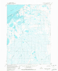
1963 Map of Chignik C-4
USGS Topo · Published 1972About this map
Bristol Bay dominates the northern reaches of this coastal landscape, where the tides shape a complex network of Tidal Flats and offshore Seal Islands. Further inland, the terrain is defined by a saturated tundra environment, heavily marked by the Unangashak River and its various tributaries. The presence of numerous unnamed lakes and ponds alongside named waterways like Blueberry Creek, Fireweed Creek, and Crater Creek suggests a low-lying, water-dominant topography characteristic of the Alaska Peninsula. Based on photogrammetric methods from the late 1950s and early 1960s, the map provides a look at an unsurveyed wilderness where land lines were predetermined by the Bureau of Land Management rather than established by ground survey. The lack of roads or trails throughout the quadrangle highlights the total reliance on maritime and riverine geography for navigation during this era.
Find a feature on this map
7 named features on this map. Tap any name to fly to it.
Don’t see what you’re looking for? This feature index may not catch every label — zoom into the map to look around manually.
Map Details
Editions of this 1963 Chignik C-4 Map
2 editions found
Other maps of this area

1963 · Chignik C-3
USGS Topo · 1:63,360

1963 · Chignik C-4
USGS Topo · 1:63,360

1963 · Chignik B-5
USGS Topo · 1:63,360

1963 · Chignik B-4
USGS Topo · 1:63,360
1963 · Chignik D-4
USGS Topo · 1:63,360

1963 · Chignik D-3
USGS Topo · 1:63,360

1963 · Chignik B-3
USGS Topo · 1:63,360

1963 · Chignik C-5
USGS Topo · 1:63,360

1963 · Chignik
USGS Topo · 1:250,000
2020 · Chignik B-5 NE
USGS Topo · 1:25,000