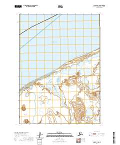
2020 Map of Chignik C-6 SE
USGS Topo · Published 2020About this map
Bristol Bay dominates the northern landscape of this coastal Alaskan region, where the vast waters meet a complex network of wetlands and tidal inlets. The shoreline is defined by the outflow of the Ocean River, which winds through a low-lying terrain characterized by numerous unnamed ponds and small water bodies. This area, situated within the Aleutians East Borough, shows a landscape shaped by glacial and alluvial processes, with the Three Hills providing a rare point of elevation in an otherwise horizontal expanse of tundra. Further inland, Ilnik Lake serves as a significant hydrologic feature, situated amidst a grid of township and range lines including t41s r66w and t42s r66w. The map documents a remote wilderness where natural watercourses and the shifting coastal interface are the primary geographical markers.
Find a feature on this map
7 named features on this map. Tap any name to fly to it.
Don’t see what you’re looking for? This feature index may not catch every label — zoom into the map to look around manually.
Map Details
Editions of this 2020 Chignik C-6 SE Map
This is the sole edition of this map. No revisions or reprints were ever made.
Other maps of this area

1963 · Chignik B-5
USGS Topo · 1:63,360

1963 · Chignik B-6
USGS Topo · 1:63,360
1963 · Chignik C-6
USGS Topo · 1:63,360

1963 · Chignik C-5
USGS Topo · 1:63,360

1963 · Chignik
USGS Topo · 1:250,000
2020 · Chignik B-6 NW
USGS Topo · 1:25,000
2020 · Chignik B-5 NW
USGS Topo · 1:25,000
2020 · Chignik C-6 SW
USGS Topo · 1:25,000
2020 · Chignik C-5 NW
USGS Topo · 1:25,000
2020 · Chignik B-6 NE
USGS Topo · 1:25,000