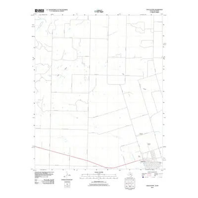
2010 Map of Chillicothe
USGS Topo · Published 2010About this map
Chillicothe serves as the focal point for this Hardeman County landscape, situated near the winding path of Wanderers Creek. The settlement pattern reflects the traditional Texas grid system, bounded by significant local landmarks such as the Chillicothe Cemetery and Barnett Airport. To the north, the terrain is defined by the Red River, which forms the natural boundary between Texas and Oklahoma. This survey illustrates a well-developed network of farm-to-market roads, including FM 2008 and FM 2006, connecting outlying rural properties across the drainage basins of Groesbeck Creek and Horse Creek. The agricultural character of the region is further evidenced by named topographical features like Ewell Hollow and Plum Hollow, providing a clear view of the area's geography and infrastructure as it existed in the early 21st century.
Find a feature on this map
41 named features on this map. Tap any name to fly to it.
Don’t see what you’re looking for? This feature index may not catch every label — zoom into the map to look around manually.
Map Details
Editions of this 2010 Chillicothe Map
This is the sole edition of this map. No revisions or reprints were ever made.
Other maps of this area

1955 · Lawton
USGS Topo · 1:250,000

1958 · Vernon
USGS Topo · 1:62,500

1958 · Medicine Mound
USGS Topo · 1:62,500

1958 · Elmer
USGS Topo · 1:62,500

1960 · Quanah
USGS Topo · 1:62,500

1975 · Quanah NE
USGS Topo · 1:24,000

1975 · Quanah NW
USGS Topo · 1:24,000

1983 · Tolbert
USGS Topo · 1:24,000

1983 · Big Mound
USGS Topo · 1:24,000
1983 · Medicine Mound
USGS Topo · 1:24,000