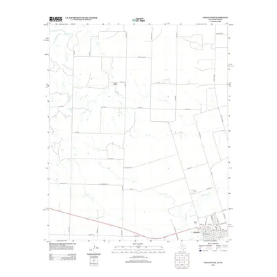
2012 Map of Chillicothe
USGS Topo · Published 2012About this map
The Red River forms the northern boundary of this Hardeman County landscape, where the flat plains of north Texas meet the Oklahoma border. The town of Chillicothe serves as the primary hub, showing a grid of streets such as S 1st St and S 8th St south of the main rail corridor. This 2012 survey illustrates a sprawling network of rural roads named after local families and landmarks, including Boyd Loop, Hamm Rd, and Moffett Rd. Near the center of the quadrangle, the small settlement at Ewell Hollow sits among drainage patterns leading toward the river. To the northeast of the main town site, the Chillicothe Cem provides a point of interest for genealogists tracing local families in this agricultural region. The drainage of Groesbeck Cr and the winding path of Wanderers Cr further define the local topography.
Find a feature on this map
52 named features on this map. Tap any name to fly to it.
Don’t see what you’re looking for? This feature index may not catch every label — zoom into the map to look around manually.
Map Details
Editions of this 2012 Chillicothe Map
This is the sole edition of this map. No revisions or reprints were ever made.
Other maps of this area

1955 · Lawton
USGS Topo · 1:250,000

1958 · Vernon
USGS Topo · 1:62,500

1958 · Medicine Mound
USGS Topo · 1:62,500

1958 · Elmer
USGS Topo · 1:62,500

1960 · Quanah
USGS Topo · 1:62,500

1975 · Quanah NE
USGS Topo · 1:24,000

1975 · Quanah NW
USGS Topo · 1:24,000

1983 · Tolbert
USGS Topo · 1:24,000

1983 · Big Mound
USGS Topo · 1:24,000
1983 · Medicine Mound
USGS Topo · 1:24,000