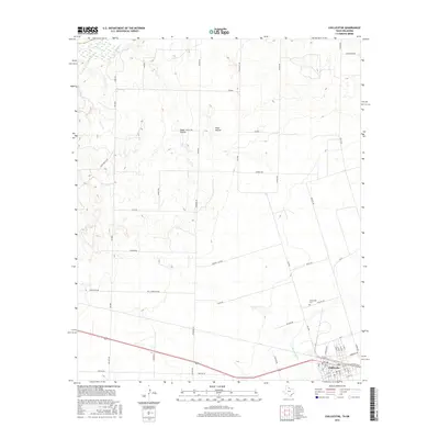
2016 Map of Chillicothe
USGS Topo · Published 2016About this map
Chillicothe serves as the primary hub in this corner of Hardeman County, situated just south of the state line. The landscape is defined by the winding course of the Red River to the north and the drainage systems of Wanderer's Cr and Horse Cr. Notable topographic depressions such as Plum Hollow and Ewell Hollow interrupt the plains, while a grid of rural roads—including Lewis Rd and Taylor Rd—connects the outlying agricultural land back to the town center. Genealogists and local historians will find the Chillicothe Cem clearly marked on the eastern edge of the settlement near Phillips Rd. The map illustrates the 2016 layout of this Texas-Oklahoma borderlands community, highlighting the intersection of rail infrastructure and local thoroughfares like Ave G and N 1st St.
Find a feature on this map
63 named features on this map. Tap any name to fly to it.
Don’t see what you’re looking for? This feature index may not catch every label — zoom into the map to look around manually.
Map Details
Editions of this 2016 Chillicothe Map
This is the sole edition of this map. No revisions or reprints were ever made.
Other maps of this area

1955 · Lawton
USGS Topo · 1:250,000

1958 · Vernon
USGS Topo · 1:62,500

1958 · Medicine Mound
USGS Topo · 1:62,500

1958 · Elmer
USGS Topo · 1:62,500

1960 · Quanah
USGS Topo · 1:62,500

1975 · Quanah NE
USGS Topo · 1:24,000

1975 · Quanah NW
USGS Topo · 1:24,000

1983 · Tolbert
USGS Topo · 1:24,000

1983 · Big Mound
USGS Topo · 1:24,000
1983 · Medicine Mound
USGS Topo · 1:24,000