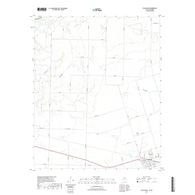
2019 Map of Chillicothe
USGS Topo · Published 2019About this map
Chillicothe serves as the primary hub in this corner of Hardeman County, situated where the plains meet the southern banks of the Red River. The township's layout is defined by a traditional grid oriented along major transit corridors, including the rail-adjacent FM 91 and the primary east-west route of US Highway 287. To the north, the terrain becomes increasingly textured as the land descends into Ewell Hollow and Plum Hollow, drainage systems that feed toward the river valley. Local family names and agricultural history are preserved in the naming of rural routes such as Joe Bob Rd, Huneycutt Rd, and Potts Rd. The community’s heritage is anchored at the Chillicothe Cemetery, while the seasonal flow of Wanderers Creek and Horse Creek dictates the movement of water across this ranching and farming landscape.
Find a feature on this map
64 named features on this map. Tap any name to fly to it.
Don’t see what you’re looking for? This feature index may not catch every label — zoom into the map to look around manually.
Map Details
Editions of this 2019 Chillicothe Map
This is the sole edition of this map. No revisions or reprints were ever made.
Other maps of this area

1955 · Lawton
USGS Topo · 1:250,000

1958 · Vernon
USGS Topo · 1:62,500

1958 · Medicine Mound
USGS Topo · 1:62,500

1958 · Elmer
USGS Topo · 1:62,500

1960 · Quanah
USGS Topo · 1:62,500

1975 · Quanah NE
USGS Topo · 1:24,000

1975 · Quanah NW
USGS Topo · 1:24,000

1983 · Tolbert
USGS Topo · 1:24,000

1983 · Big Mound
USGS Topo · 1:24,000
1983 · Medicine Mound
USGS Topo · 1:24,000