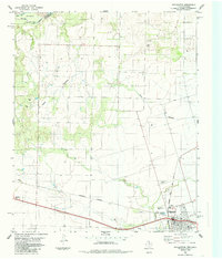
1984 Map of Chillicothe
USGS Topo · Published 1985About this map
Chillicothe serves as the focal point of this Hardeman County landscape, situated at a vital junction of the Burlington Northern and the Atchison Topeka and Santa Fe railroads. The town's economic foundations are evident in the presence of a Grain Elevator and a network of Oil Wells scattered to the north. The terrain is defined by the drainage systems of Wanderers Creek and Groesbeck Creek, which flow toward the Red River at the Oklahoma border. Local land use is further illustrated by the inclusion of a Cemetery and multiple Gravel Pits, alongside infrastructure such as Sewage Disposal Ponds and a Roadside Park along Highway 287. The map documents a period where agricultural storage and fossil fuel extraction shared the land with extensive rail corridors, marking a point of transition in North Texas industry and transport.
Find a feature on this map
18 named features on this map. Tap any name to fly to it.
Don’t see what you’re looking for? This feature index may not catch every label — zoom into the map to look around manually.
Map Details
Editions of this 1984 Chillicothe Map
This is the sole edition of this map. No revisions or reprints were ever made.
Other maps of this area

1955 · Lawton
USGS Topo · 1:250,000

1958 · Vernon
USGS Topo · 1:62,500

1958 · Medicine Mound
USGS Topo · 1:62,500

1958 · Elmer
USGS Topo · 1:62,500

1960 · Quanah
USGS Topo · 1:62,500

1975 · Quanah NE
USGS Topo · 1:24,000

1975 · Quanah NW
USGS Topo · 1:24,000

1983 · Tolbert
USGS Topo · 1:24,000

1983 · Big Mound
USGS Topo · 1:24,000
1983 · Medicine Mound
USGS Topo · 1:24,000