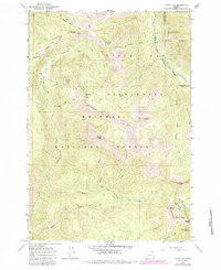
1965 Map of China Cap
USGS Topo · Published 1985About this map
The Minam River flows through the high backcountry of the Wallowa National Forest in this mid-1960s topographic survey. The map details a landscape where primitive travel is the primary means of access, evidenced by an extensive network of named paths including the Cartwheel Trail and the Pack Trail winding through the Eagle Cap Wilderness. Human presence is sparse, centered on the Catherine Creek Cabin and the Mule Peak Lookout, indicating the area's primary use for forest management and livestock grazing.
Find a feature on this map
82 named features on this map. Tap any name to fly to it.
Don’t see what you’re looking for? This feature index may not catch every label — zoom into the map to look around manually.
Map Details
Editions of this 1965 China Cap Map
2 editions found
Other maps of this area

1906 · Telocaset
USGS Topo · 1:125,000

1954 · Eagle Cap
USGS Topo · 1:62,500

1955 · Grangeville
USGS Topo · 1:250,000

1957 · Enterprise
USGS Topo · 1:62,500

1959 · Grangeville
USGS Topo · 1:250,000

1965 · China Cap
USGS Topo · 1:24,000

1965 · Flagstaff Butte
USGS Topo · 1:24,000

1965 · Medical Springs
USGS Topo · 1:24,000

1965 · Little Catherine Creek
USGS Topo · 1:24,000
1965 · Mt. Fanny
USGS Topo · 1:24,000