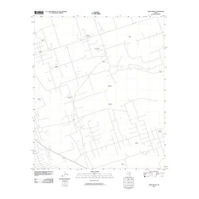
2010 Map of China Ranch
USGS Topo · Published 2010About this map
China Ranch sits at the heart of this landscape, surrounded by an extensive network of industrial energy infrastructure and dispersed water sources. The area is defined by its role in the Texas petroleum industry, evidenced by the North Monahans Oil Field, Monahans Oil Field, and Halley Oil Field. Processing facilities like the Halley Gas Plant and the Monahans GasolinePlant are connected by a web of service roads, including Co RD 404. Interspliced with this energy landscape are numerous named landmarks like North Camp Windmill, LittleRedtop Windmill, and Humble Windmill, which reflect the region's ranching heritage and the vital importance of groundwater in this arid environment.
Find a feature on this map
22 named features on this map. Tap any name to fly to it.
Don’t see what you’re looking for? This feature index may not catch every label — zoom into the map to look around manually.
Map Details
Editions of this 2010 China Ranch Map
This is the sole edition of this map. No revisions or reprints were ever made.
Other maps of this area

1954 · Pecos
USGS Topo · 1:250,000

1957 · Pecos
USGS Topo · 1:250,000

1968 · Monahans SE
USGS Topo · 1:24,000

1968 · Cowden Place
USGS Topo · 1:24,000

1968 · China Ranch
USGS Topo · 1:24,000

1969 · Pyote NE
USGS Topo · 1:24,000

1969 · Pyote East
USGS Topo · 1:24,000

1969 · Monahans
USGS Topo · 1:24,000

1970 · Kermit
USGS Topo · 1:24,000
1971 · Amburgey Ranch
USGS Topo · 1:24,000