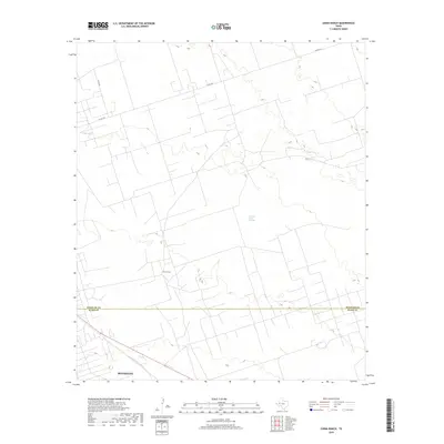
2019 Map of China Ranch
USGS Topo · Published 2019About this map
Buzzard Roost Springs provides a rare water marker in this arid West Texas landscape, situated north of the China Ranch settlement. The map documents a sparsely populated region where the administrative boundary between Winkler and Ward counties cuts across open ranchland and scrub. Development is primarily centered around the northern edge of Monahans in the southwest corner of the sheet, while a network of county roads, including Co Rd 404, provides the essential infrastructure for the area's sprawling cattle and ranching operations. The terrain is characterized by subtle elevation shifts and intermittent drainage patterns that define the local topography.
Find a feature on this map
5 named features on this map. Tap any name to fly to it.
Don’t see what you’re looking for? This feature index may not catch every label — zoom into the map to look around manually.
Map Details
Editions of this 2019 China Ranch Map
This is the sole edition of this map. No revisions or reprints were ever made.
Other maps of this area

1954 · Pecos
USGS Topo · 1:250,000

1957 · Pecos
USGS Topo · 1:250,000

1968 · Monahans SE
USGS Topo · 1:24,000

1968 · Cowden Place
USGS Topo · 1:24,000

1968 · China Ranch
USGS Topo · 1:24,000

1969 · Pyote NE
USGS Topo · 1:24,000

1969 · Pyote East
USGS Topo · 1:24,000

1969 · Monahans
USGS Topo · 1:24,000

1970 · Kermit
USGS Topo · 1:24,000
1971 · Amburgey Ranch
USGS Topo · 1:24,000