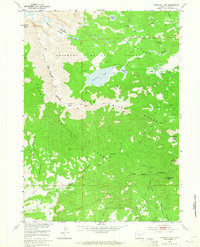
1953 Map of Christina Lake
USGS Topo · Published 1965About this map
Wind River Range dominates this 1950s high-altitude survey, where the Continental Divide separates the headwaters of the Missouri River Basin from the Pacific drainage. The topography is defined by prominent summits such as Atlantic Peak and Granite Peak, which overlook the deep incision of Atlantic Canyon. At the heart of the landscape lies Christina Lake, a significant water body situated below Christina Pass. The map documents a network of primitive routes essential for mountain navigation, including the Louis Lake Trail and Sioux Pass Trail. To the south, the terrain transitions into the upper reaches of the Little Sweetwater River and East Sweetwater River, illustrating the complex hydrology of the Shoshone and Bridger national forests during this era of post-war federal land management.
Find a feature on this map
29 named features on this map. Tap any name to fly to it.
Don’t see what you’re looking for? This feature index may not catch every label — zoom into the map to look around manually.
Map Details
Editions of this 1953 Christina Lake Map
3 editions found
Other maps of this area

1953 · Sweetwater Gap
USGS Topo · 1:24,000

1953 · Cony Mountain
USGS Topo · 1:24,000

1953 · Fossil Hill
USGS Topo · 1:24,000

1953 · Louis Lake
USGS Topo · 1:24,000

1953 · South Pass City
USGS Topo · 1:24,000

1953 · Christina Lake
USGS Topo · 1:24,000

1955 · Lander
USGS Topo · 1:250,000

1958 · Lander
USGS Topo · 1:250,000

1958 · Parting of the Ways
USGS Topo · 1:62,500

1961 · Lander
USGS Topo · 1:250,000