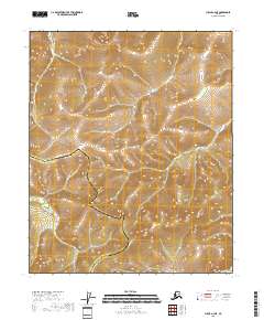
2018 Map of Circle A-4 NE
USGS Topo · Published 2018About this map
The N Fork Chena River winds through the southwestern portion of this interior Alaskan landscape, marking a significant drainage point within the Fairbanks North Star Borough and Yukon-Koyukuk Census Area borderlands. The terrain is defined by a series of steep ridges and high-elevation drainages including Denver Cr to the north and Acme Cr centrally. The layout of these watercourses, including Milburn Cr, reveals a watershed structure unaffected by modern infrastructure, preserving the natural flow of the North Fork tributaries as they were surveyed in 2018. This map provides a detailed record of the undeveloped transition between the Fairbanks North Star Borough and the Yukon-Koyukuk Census Area, essential for understanding the remote hydrology of the Chena River headwaters.
Find a feature on this map
11 named features on this map. Tap any name to fly to it.
Don’t see what you’re looking for? This feature index may not catch every label — zoom into the map to look around manually.
Map Details
Editions of this 2018 Circle A-4 NE Map
This is the sole edition of this map. No revisions or reprints were ever made.
Other maps of this area

1951 · Circle
USGS Topo · 1:250,000

1952 · Circle A-4
USGS Topo · 1:63,360

1952 · Circle B-4
USGS Topo · 1:63,360

1955 · Circle B-3
USGS Topo · 1:63,360

1955 · Circle A-3
USGS Topo · 1:63,360

1955 · Circle
USGS Topo · 1:250,000

1964 · Circle
USGS Topo · 1:250,000
2018 · Circle B-3 SW
USGS Topo · 1:25,000
2018 · Circle A-3 SW
USGS Topo · 1:25,000
2018 · Circle A-4 NW
USGS Topo · 1:25,000