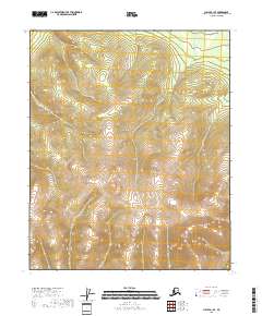
2018 Map of Circle B-1 SE
USGS Topo · Published 2018About this map
Steep, high-elevation terrain dominates this interior Alaska quadrangle within the Yukon-Koyukuk Census Area. The topography is defined by significant vertical relief, with numerous ridges and drainage systems branching out from central high points. The map area is organized across four township and range blocks, including T6n R17e, T6n R18e, T5n R17e, and T5n R18e. Absent of any named roads, settlements, or structures, the landscape represents a pristine wilderness environment. The contour lines, provided by the National Elevation Dataset, reveal a complex network of peaks and valleys, where the natural water flow is documented through the National Hydrography Dataset across this roadless expanse of the Alaskan interior.
Find a feature on this map
4 named features on this map. Tap any name to fly to it.
Don’t see what you’re looking for? This feature index may not catch every label — zoom into the map to look around manually.
Map Details
Editions of this 2018 Circle B-1 SE Map
This is the sole edition of this map. No revisions or reprints were ever made.
Other maps of this area

1951 · Charley River
USGS Topo · 1:250,000

1951 · Circle
USGS Topo · 1:250,000

1955 · Circle A-1
USGS Topo · 1:63,360

1955 · Circle B-1
USGS Topo · 1:63,360

1955 · Circle
USGS Topo · 1:250,000

1956 · Charley River B-6
USGS Topo · 1:63,360

1956 · Charley River A-6
USGS Topo · 1:63,360

1956 · Charley River
USGS Topo · 1:250,000

1964 · Circle
USGS Topo · 1:250,000
2018 · Circle A-1 NE
USGS Topo · 1:25,000