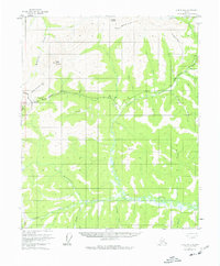
1952 Map of Circle B-4
USGS Topo · Published 1977About this map
Twelvemile Summit serves as a critical high point in this interior Alaskan landscape, where the Steese Highway traverses the divide between the Yukon and Tanana drainage basins. The map illustrates a region defined by its waterway network, dominated by the winding course of North Fork Birch Creek and its many tributaries like Fryingpan Creek and Harrington Creek.
Find a feature on this map
26 named features on this map. Tap any name to fly to it.
Don’t see what you’re looking for? This feature index may not catch every label — zoom into the map to look around manually.
Map Details
Editions of this 1952 Circle B-4 Map
4 editions found
Other maps of this area

1951 · Circle
USGS Topo · 1:250,000

1951 · Circle A-5
USGS Topo · 1:63,360

1952 · Circle A-4
USGS Topo · 1:63,360

1952 · Circle B-4
USGS Topo · 1:63,360

1952 · Circle C-4
USGS Topo · 1:63,360

1952 · Circle C-5
USGS Topo · 1:63,360

1952 · Circle A-5
USGS Topo · 1:63,360

1954 · Circle C-5
USGS Topo · 1:63,360

1954 · Circle A-5
USGS Topo · 1:63,360

1954 · Circle B-5
USGS Topo · 1:63,360