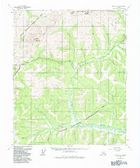
1952 Map of Circle B-4
USGS Topo · Published 1984About this map
The Steese Highway carves through the interior Alaskan interior, crossing the high point at Twelvemile Summit and connecting the regional waterways. This 1952 survey, field annotated during the mid-century, reveals the early infrastructure and hydraulic geography of the Fairbanks North Star Borough and the surrounding wilderness. The landscape is dominated by the complex drainage systems of the North Fork Birch Creek and South Fork Birch Creek, which served as critical landmarks for early prospecting and travel. Evidence of resource extraction is found near Eagle Creek at a Placer Mine, while the higher elevations are marked by Table Mountain and Pinnell Mountain. The transition between the peaks and the low-lying drainage basins of Twelvemile Creek and Fryingpan Creek highlights the difficulty of traversing this area before modern improvements.
Find a feature on this map
27 named features on this map. Tap any name to fly to it.
Don’t see what you’re looking for? This feature index may not catch every label — zoom into the map to look around manually.
Map Details
Editions of this 1952 Circle B-4 Map
4 editions found
Other maps of this area

1951 · Circle
USGS Topo · 1:250,000

1951 · Circle A-5
USGS Topo · 1:63,360

1952 · Circle A-4
USGS Topo · 1:63,360

1952 · Circle B-4
USGS Topo · 1:63,360

1952 · Circle C-4
USGS Topo · 1:63,360

1952 · Circle C-5
USGS Topo · 1:63,360

1952 · Circle A-5
USGS Topo · 1:63,360

1954 · Circle C-5
USGS Topo · 1:63,360

1954 · Circle A-5
USGS Topo · 1:63,360

1954 · Circle B-5
USGS Topo · 1:63,360