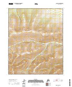
2018 Map of Circle C-3 SW
USGS Topo · Published 2018About this map
Porcupine Cr and its many tributaries carve through the interior of the Yukon-Koyukuk Census Area in this 2018 survey. The landscape is defined by a dense network of watercourses and topographical depressions, including Grosgnon Gulch and Caribou Gulch in the southern portion of the quadrangle. These features suggest a terrain deeply tied to the history of mineral exploration and prospecting in the Alaskan interior, where drainage systems like Yankee Cr and Bonanza Cr often dictated the location of mining claims.
Find a feature on this map
15 named features on this map. Tap any name to fly to it.
Don’t see what you’re looking for? This feature index may not catch every label — zoom into the map to look around manually.
Map Details
Editions of this 2018 Circle C-3 SW Map
This is the sole edition of this map. No revisions or reprints were ever made.
Other maps of this area

1951 · Circle
USGS Topo · 1:250,000

1952 · Circle B-4
USGS Topo · 1:63,360

1952 · Circle C-4
USGS Topo · 1:63,360

1955 · Circle B-3
USGS Topo · 1:63,360

1955 · Circle C-3
USGS Topo · 1:63,360

1955 · Circle
USGS Topo · 1:250,000

1964 · Circle
USGS Topo · 1:250,000
2018 · Circle C-4 SE
USGS Topo · 1:25,000
2018 · Circle B-4 NE
USGS Topo · 1:25,000
2018 · Circle C-3 NE
USGS Topo · 1:25,000