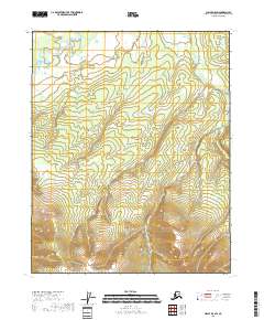
2018 Map of Circle D-5 SW
USGS Topo · Published 2018About this map
Beaver Creek meanders through a landscape of expansive wetlands and rising terrain in this 2018 survey of the Alaskan interior. The map illustrates a transitional geography where the low-lying drainage of the creek gives way to significant elevation changes, marked by the boundaries of t12n r6e, t12n r7e, t11n r6e, and t11n r7e. This part of the Yukon-Koyukuk Census Area is characterized by its lack of established infrastructure, roads, or named settlements, highlighting the remote nature of the region. The data, synthesized from the National Hydrography Dataset and National Elevation Dataset, provides a technical baseline for the topography surrounding the creek's upper reaches.
Find a feature on this map
5 named features on this map. Tap any name to fly to it.
Don’t see what you’re looking for? This feature index may not catch every label — zoom into the map to look around manually.
Map Details
Editions of this 2018 Circle D-5 SW Map
This is the sole edition of this map. No revisions or reprints were ever made.
Other maps of this area

1951 · Circle
USGS Topo · 1:250,000

1951 · Circle D-6
USGS Topo · 1:63,360

1951 · Circle C-6
USGS Topo · 1:63,360

1952 · Circle D-5
USGS Topo · 1:63,360

1952 · Circle C-5
USGS Topo · 1:63,360

1954 · Circle C-5
USGS Topo · 1:63,360

1954 · Circle D-5
USGS Topo · 1:63,360

1954 · Circle D-6
USGS Topo · 1:63,360
1954 · Circle C-6
USGS Topo · 1:63,360

1955 · Circle
USGS Topo · 1:250,000