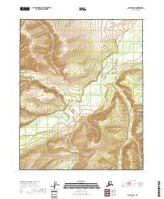
2018 Map of Circle D-6 SE
USGS Topo · Published 2018About this map
Beaver Creek meanders through the heart of this landscape, its complex braided channels and surrounding wetlands defining the drainage patterns of the Yukon-Koyukuk region. In the northern reaches, Glacier Cr flows south to join the main waterway, while the western terrain is marked by the winding courses of Victoria Creek and Sand Cr. The presence of these numerous tributaries, including Moose Cr and Yellow Cr, suggests a highly dynamic alluvial environment where water levels and channel paths shift over time. Surveyed by the U.S. Geological Survey, the area is divided by the township lines of T11N and T12N, reflecting the systematic grid applied to this undeveloped Alaskan wilderness.
Find a feature on this map
11 named features on this map. Tap any name to fly to it.
Don’t see what you’re looking for? This feature index may not catch every label — zoom into the map to look around manually.
Map Details
Editions of this 2018 Circle D-6 SE Map
This is the sole edition of this map. No revisions or reprints were ever made.
Other maps of this area

1951 · Circle
USGS Topo · 1:250,000

1951 · Circle D-6
USGS Topo · 1:63,360

1951 · Circle C-6
USGS Topo · 1:63,360

1952 · Circle D-5
USGS Topo · 1:63,360

1952 · Circle C-5
USGS Topo · 1:63,360

1954 · Circle C-5
USGS Topo · 1:63,360

1954 · Circle D-5
USGS Topo · 1:63,360

1954 · Circle D-6
USGS Topo · 1:63,360
1954 · Circle C-6
USGS Topo · 1:63,360

1955 · Circle
USGS Topo · 1:250,000