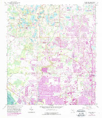
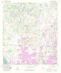
1956 Map of Citrus Park
USGS Topo · Published 1987About this map
Citrus Park and the surrounding Hillsborough County lake district are defined by an intricate network of freshwater basins and cypress stands in this mid-century survey, updated with late-1980s urban expansion. The landscape transitions from the dense clusters of Trailer Park developments and nascent suburbs in the south to the more open, wetland-rich terrain of the north. Significant water bodies like Keystone Lake, Lake Rogers, and Starvation L dominate the topography, connected by the drainage of Rocky Creek and Brooker Creek. Local community life is anchored by landmarks such as the Keystone Ch and Camp Brorein, while the CSX railroad corridor and local sandpits reflect the area's logistical and extractive history. The 1987 revisions, shown in purple, illustrate the rapid suburbanization pushing into formerly rural sections of the county near Lake Park.
Find a feature on this map
53 named features on this map. Tap any name to fly to it.
Don’t see what you’re looking for? This feature index may not catch every label — zoom into the map to look around manually.
Map Details
Editions of this 1956 Citrus Park Map
5 editions found
Other maps of this area

1921 · Tampa
USGS Topo · 1:62,500

1921 · St Petersburg
USGS Topo · 1:62,500

1943 · Gandy Bridge
USGS Topo · 1:31,680

1943 · Safety Harbor
USGS Topo · 1:31,680

1943 · Odessa
USGS Topo · 1:24,000

1943 · Elfers
USGS Topo · 1:24,000

1943 · Lutz
USGS Topo · 1:24,000

1943 · Oldsmar
USGS Topo · 1:24,000

1944 · Sulphur Springs
USGS Topo · 1:31,680

1944 · Tampa
USGS Topo · 1:31,680