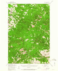
1950 Map of Clancy
USGS Topo · Published 1963About this map
The Northern Pacific corridor serves as a primary artery through this mountainous region of the Helena National Forest and Deerlodge National Forest. At the northern edge, the community of Clancy sits along Prickly Pear Creek, accompanied by Alhambra and the nearby McClellan Ranger Station. The landscape is defined by its deep mining heritage, evident in the numerous named operations like the Golden Age Mine, Tiger Mine, and the southern settlement of Elkhorn. The rugged interior is punctuated by prominent summits including Casey Peak, Elkhorn Peak, and Crow Peak, while numerous drainages such as Lump Gulch and Warm Springs navigate the complex topography. This map documents a high-altitude wilderness where mining and forestry intersected with early Montana infrastructure, preserving the locations of remote outposts like the Eagle Creek Ranger Station and scenic landmarks such as Crow Creek Falls.
Find a feature on this map
75 named features on this map. Tap any name to fly to it.
Don’t see what you’re looking for? This feature index may not catch every label — zoom into the map to look around manually.
Map Details
Editions of this 1950 Clancy Map
5 editions found

Other maps of this area

1886 · Fort Logan
USGS Topo · 1:250,000

1889 · Helena
USGS Topo · 1:250,000

1893 · Helena
USGS Topo · 1:250,000

1899 · Boulder
USGS Topo · 1:125,000

1899 · Helena
USGS Topo · 1:62,500

1899 · Helena
USGS Topo · 1:250,000

1903 · Helena
USGS Topo · 1:250,000

1947 · Butte
USGS Topo · 1:250,000

1948 · White Sulphur Springs
USGS Topo · 1:250,000

1949 · Radersburg
USGS Topo · 1:62,500