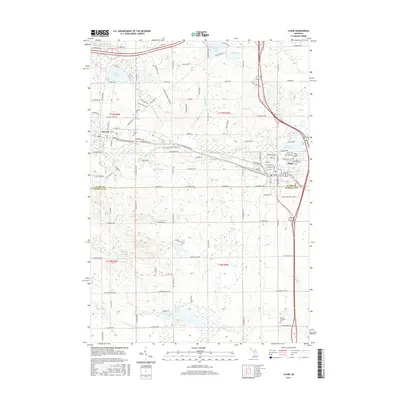
2017 Map of Clare
USGS Topo · Published 2017About this map
The Tobacco River and its various tributaries, including Newton Cr and Sanford Cr, carve through this central Michigan landscape at the border of Clare and Isabella counties. The town of Clare serves as a local hub, featuring Lake Shamrock and the Saint Cecilia church, while the village of Farwell lies to the west along the Pere Marquette State Trail. This corridor follows the historic path of the railroad, a legacy further evidenced by the Harrison Railroad Grade Rd north of the main settlement. Numerous kettle lakes such as Lake Thirteen, Otter Lake, and Stevenson Lake dot the glaciated terrain, providing a look at the region's natural hydrography alongside developed areas. Genealogists will find several local burial grounds, including Cherry Grove Cem, Surrey Cem, and the Vernon Township Cem to the south.
Find a feature on this map
95 named features on this map. Tap any name to fly to it.
Don’t see what you’re looking for? This feature index may not catch every label — zoom into the map to look around manually.
Map Details
Editions of this 2017 Clare Map
This is the sole edition of this map. No revisions or reprints were ever made.
Other maps of this area

1916 · Mount Pleasant
USGS Topo · 1:62,500

1919 · Mount Pleasant
USGS Topo · 1:62,500

1930 · Shepherd
USGS Topo · 1:48,000

1936 · Shepherd
USGS Topo · 1:62,500

1943 · Mount Pleasant
USGS Topo · 1:62,500

1954 · Midland
USGS Topo · 1:250,000

1958 · Midland
USGS Topo · 1:250,000

1959 · Midland
USGS Topo · 1:250,000

1959 · Clare
USGS Topo · 1:62,500

1966 · Midland
USGS Topo · 1:250,000